Pensioners Corner
 Screen Reader Access
 Skip to main content


Disaster Management: Synthesis of Modelling, Measurements and Data Analytics
Disaster Management: Synthesis of Modelling, Measurements and Data Analytics
Only possible way to tackle any disaster is to manage it with careful planning and preparation. CSIR Fourth Paradigm Institute is recognised at national and global level for its multi-dimensional high impact studies of the earth system covering the four geographic spheres for over three decades to address various aspects of disaster. This is supported by world class supercomputing facility hosted at our institute. Further, we have initiated domain agnostic AI & ML to several domains including disaster management. Our high impact scientific publications and citations indicate the global relevance of our research. We received several prestigious national (CSIR Bhatnagar, National Mineral/Geoscience), state (CV Raman etc..) and young scientist (CSIR, INSA) awards for our work.
Seismic Hazard: We pioneered Global Positioning System (GPS) based natural hazard studies in India since 1994, when GPS was made fully operational. For the first time, two decades of continuous GPS data is analysed to determine surface crustal motion of Indian tectonic plate precisely. Inverse modelling, integration of GPS and broadband seismic data give the slip along major faults and crustal strain rates along seismically active boundaries and plate interiors of Indian tectonic plate. These models estimated magnitude and recurrence interval of major earthquakes. Further, we initiated earthquake precursor studies using AI of ground motion data as well as GPS derived Total Electron Content (TEC) in ionosphere.
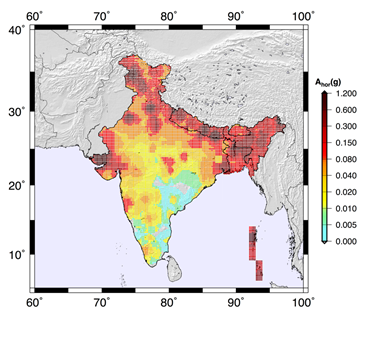
Figure indicates the Earthquake Hazard of India, high risk (0.6 to1.2g) to low risk (0 to 0.01g)
We gave earthquake hazard map (figure) of India and adjacent regions using neo-deterministic approach based on modeling and computation of synthetic seismograms which provide seismic hazard parameters (peak ground motion, response spectra etc.). Such reliable and comprehensive characterization of expected earthquake ground motion is essential to improve the building codes, particularly for the protection of critical infrastructures and for land use planning. Further, subsurface soft sediments amplify the ground motion which varies significantly within a 100m range. Mapping such high variation in terms of fundamental frequency and corresponding amplification, we provided site specific microzonation maps for Delhi, Ahmedabad, Bangalore and Srinagar cities.
Climate change and Impact: A modelling framework relevant for multiple scales in the climate system are combined to generate an effective simulation of global climate, in particular the Indian Monsoon. Also a dynamical downscaling climate modelling framework is developed for generating kilometre resolution climate change projections for agricultural yields of rice crops. In health sector, using predicted weather parameters and models, malaria parameters (incidences, number of mosquitoes etc.) are predicted for planning and implementing epidemic preparedness of vector-borne diseases.
High impact hydro-meteorological disasters are forecasted using state-of-the-art meso-scale modeling platform for extreme rainfall events, heat waves, tropical cyclones etc. The impact of land use changes and urbanization on the genesis and evolution of the extreme rainfall events (like Uttarakhand event in June 2013) are quantified in the meso-scale modeling framework. The heat wave over Odisha and the temperature duration frequency analysis over mega cities like Delhi and Bangalore are analyzed.
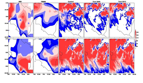
The figure shows the comparison of spatial distribution of observed (IMD and TRMM) and model simulated (3 experiments) rainfall (mm) over Uttarakhand for 16th (Top panel) & 17th (Lower panel) June 2013.
Impact analysis of urbanization on the water resources in Bangalore city using remote sensing data and historical changes over past three decades in 188 water bodies indicate substantial increase in built-up area around the lake system. A similar study using an integrated modeling system is developed to quantify the past changes in the water resources over Upper Jhelum and Kosi River basins in the Indian Himalayas. Further, to identify sustainable livelihood opportunities in two representative habitats of Indian Himalayas, assessment of past changes in different components of urban-rural ecosystem is studied through system dynamical modelling.
Carbon Cycle in ocean, atmosphere and land: Biogeochemical cycling of major (carbon, oxygen and nitrogen) and trace (phosphorous, silica, iron etc.) elements plays a key role in climate change. Robust and accurate regional estimates of the carbon and nitrogen fluxes between ocean, atmosphere and land are needed for acceptance by the international community. For the first time in India, a coupled physical-biological-chemical (PBC) model of the Indian Ocean is developed to estimate the influence of physical and biological pumps on distribution of pCO2. PBC model helps in estimating the impact of climate change on ocean upwelling, marine living resources, nutrient cycling and ocean health. Major Greenhouse gases (GHG) like Carbon dioxide (CO2), Methane (CH4), Nitrous oxide (N2O) and Carbon monoxide (CO) as per WMO standard protocols are measured at our observation stations located at Hanle, Pondicherry, Port Blair and Hosakote. This resulted in providing the longest data record of GHG’s in India and the inverse models provided robust carbon flux estimates that can help addressing gaps in atmospheric carbon cycle research.
Dr Sridevi Jade
Head
CSIR Fourth Paradigm Institute